Diego Garcia (
7°19′S 72°25′E) is an
atoll located in the heart of the
Indian Ocean, some 1,000 miles (1,600 km) south of
India's southern coast. Diego Garcia is the largest atoll by land area of the
Chagos Archipelago. It is part of the
British Indian Ocean Territory (BIOT), a
British overseas territory. Since the
depopulation of Diego Garcia in the years leading up to
1973, it has been used as a military base by the
United States. Diego Garcia hosts one of three ground antennas (others are on
Kwajalein and
Ascension Island) that assist in the operation of the Global Positioning System (
GPS) navigational system.

Now, Diego Garcia is home to a
military base jointly operated by the United States and the United Kingdom, although in practice it is largely run as a U.S. base, with only a small number of British forces and Royal Overseas Police Officers (ROPOs). The base serves as a naval refuelling and support station. It also serves as the home to Maritime Prepositioning Ship Squadron Two, the naval unit responsible for the readiness of the ships in
Military Sealift Command Prepositioning Program in the Indian Ocean, a vital strategic asset to the United States.

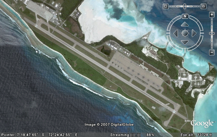
Diego Garcia also has an
airbase that supports the largest of modern
aircraft.
B-52s, other
bombers, and
aerial refueling tanker
aircraft have been deployed to Diego Garcia to execute missions to
Iraq in support of the
Iraq War and the
1991 Gulf War, and also to
Afghanistan during what the U.S. government termed
Operation Enduring Freedom, and to Iraq again during the
2003 invasion. High-tech portable shelters to support the
B-2 bomber were built on the island before the 2003 invasion of Iraq.

The B-52s,
B-1s and B-2s deployed to Diego Garcia, in anticipation of the second
Iraq War carried out the initial
aerial bombardement on
Baghdad on March 22, 2003. Some of these
bombers dropped
GPS guided bombs and
laser guided 4,200 lb.
bunker busters in "
decapitation strikes" intended to kill
Saddam Hussein and other
Baath Party officials.
[6] Diego Garcia is also a regular deployment site for US Navy
P-3C Orion maritime patrol and anti-submarine aircraft.

 Diego garcia air base

 Bomber line-up on the tarmac

 several B-52s near hangar
 another B52s

 Aerial view of Tanjung Priok Harbour
 Indonesian warship lined-up at Tanjung Priok
 another view of indonesian warship
 Several Indonesian navy research ship, The Baruna Jaya